Watershed
dxʷwuqʷəb, or Mapes Creek as it is now known, runs through the yəhaw̓ property on its eastern side. It is a south-to-north-flowing, second-order stream that flows into Lake Washington.
MAPES CREEK WATERSHED: PRE-COLONIZATION
Historian David Buerge writes of the way that the Duwamish used the land prior to colonization, including Lake Washington, which Mapes Creek flows into.
He reported that after the 1880s, “a few could recall seeing some canoes and a native gathering at one or two isolated camps,” but that they all seemed to vanish mysteriously after 1916. That was the same year that the water in Lake Washington was lowered due to the building of the ship canal, thus impacting fish habitats and wetlands where Natives foraged.
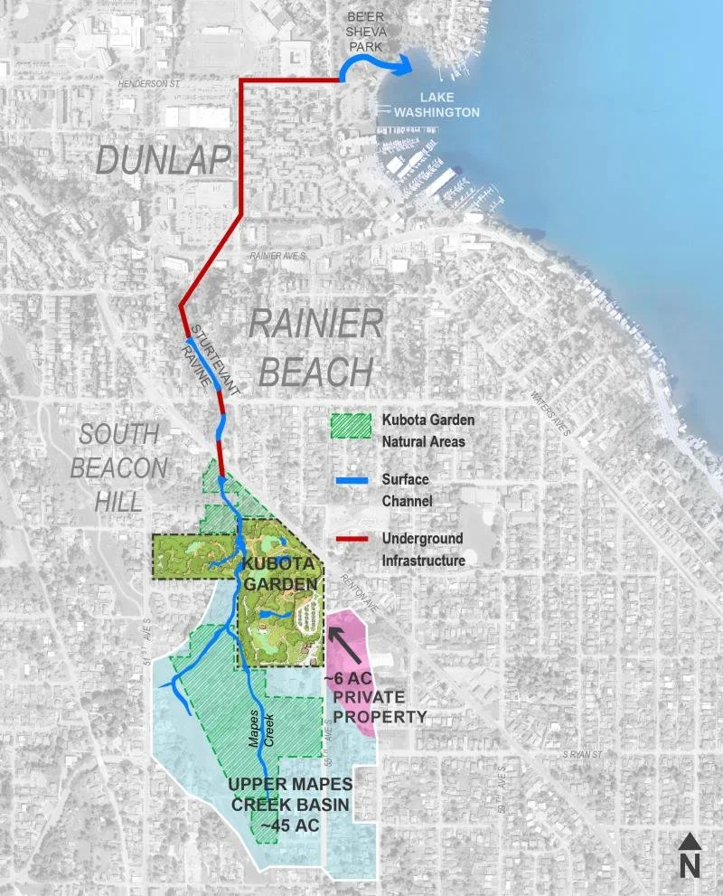
Aspect Consulting, LLC map, "Putting Data to Work," which covers "how an interactive website helped to clear up the water at Kubota Garden."
KEY
Environmental impacts due to manmade creations will be italicized.
Fish-related information will be underlined.
WATER FLOW
“In an effort to protect the integrity of the Mapes Creek watershed, whose catchment constitutes approximately 92.2 acres, the City of Seattle Department of Parks and Recreation has purchased 22 undeveloped parcels between 1991-2014.”
The various portions of Mapes Creek are as follows:
Its headwaters are in a forested green space adjacent to Kubota Gardens. They begin in “riverine wetlands that form where groundwater springs seep into an intermittent channel” which lies between two valleys within the open space.
Healthy riparian areas are an indicator of quality fish-spawning habitat. “A large proportion of the upper Mapes watershed riparian areas were found to be intact and healthy… it is possible that the upper Mapes watershed is currently or could support a resident population of cutthroat trout (Onchorynchus clarki), although the present-day low quantity and quality of spawning habitat would limit their abundance.”
Large Woody Debris (LWD) is an indicator of quality fish-spawning habitat. “The mature forest and large riparian widths indicate a potential for LWD recruitment and the development of quality habitat in the future. But the realization of these benefits could be severely limited by conditions in the lower watershed.”
“The two upper (East and West) forks of Mapes Creek are heavily forested with large riparian areas consisting of mostly deciduous trees. On both forks lateral wetlands adjacent to the creek significantly contribute to the base flow of the upper stream.”
It then flows through Kubota Gardens and its many artificial ponds and landscaped structures. These manmade structures (see above in Kubota Gardens section) were created by Fujitaro Kubota and significantly affected its waterflow. Mapes Creek, as it pertains to Kutota Gardens, is described as the following:
“Mapes Creek’s natural flow was diverted by Fujitaro Kubota in the late 1920’s when he created the ‘Necklace of Ponds,’ a series of five small pools that form one of the Garden’s key historic elements.”
“Downstream from the confluence of the East and West forks, the first major tributary flows into Mapes Creek from a right bank culvert that connects directly to the outflow of the Kubota Gardens Duck Pond. Shortly downstream from this confluence Mapes Creek is incorporated into a chain of artificial ponds and channels in the Kubota Gardens. A second right bank tributary contributes to the flow of Mapes Creek where a natural spring feeds into two adjacent ponds and eventually into the mainstem of Mapes Creek at the lowest pond in the chain. It is also at this lowest pond that an artificial left bank tributary is maintained by the pumping of water from the pond to the top of a waterfall… At the outlet of the chain of ponds Mapes Creek flows into a straightened channel for the remaining length of the park. This channelized section of creek is lined with Blackberry bushes and there is little riparian cover to shade the creek.”
Stormwater management in the park after a study by Aspect Consulting, LLC in 2020 and 2021 may have cleaned up some of the water in Kubota Gardens, thus affecting the water presently flowing through yəhaw̓. They were specifically looking to reduce sediment that was moving through the garden, and did so using customized data and mapping, stormwater management, landscape architecture, and civil engineering.
Water temperatures were appropriate for salmonids to spawn.
Fish were seen by Kubota Gardens employees in the artificial park ponds, including: one small trout, and in a December 2002 survey: threespine stickleback (Gasterosteus aculeatus) in five of the eight park ponds, and Japanese Koi (Cyprinus carpio), in two of the park’s ponds.
Manmade dams on the yəhaw̓ site (pictured below) – which were likely created by the Kubota family and remain on the site today – further affect its waterflow. Dilapidated pumphouses and significant piping on yəhaw̓’s land of indicate creek water was being used for irrigation.
“Water passes through Kubota Garden back into its natural channel at the Garden’s north property line. The creek flows north for about 150 feet before being culverted below Renton Avenue South.”
“Downstream from the Kubota Gardens, Mapes Creek flows into a series of large, shallow sediment pools created by four concrete dams or weirs. In each of these sediment pools there is a decrease in flow and the channel broadens to the width of the concrete weirs (Photos 9, 10, and 11). Three of the four weirs are completely filled with fine sediments and are no longer storing significant amounts of water. In this reach of the creek there is a mix of vegetation types in the riparian zone with mature forest dominating. The outlets of three of the four weirs are no longer functioning and water is seeping under or around the weirs.”
After leaving the yəhaw̓ property, Mapes Creek switches back and forth between surface channels and underground infrastructure – culverts that run under a mixed use urban areas beneath Renton Ave. S.
Downstream of Renton Ave. S, it then temporarily “enters a steep-sided forested ravine with homogenous riffle habitats. The upper 200 ft of this ravine was not included in the survey because a landowner denied permission to access their property, but a 60 ft section of stream just above the Roxbury culvert was accessible. Downstream from the Roxbury Street culvert, the stream is also confined in a steep-sided forested ravine dominated by simplified riffle habitats and one large sediment pool (Photo 14).”
“In its current state, the portion of Mapes Creek included in this assessment was found to offer poor habitat potential for anadromous salmonids, as exemplified by the pervasiveness of barriers to fish passage and the lack of instream habitat heterogeneity (specifically the lack of pool habitat, spawning habitat, and instream cover) important for salmonid rearing, spawning, and flow refuge.”
It then enters Sturtevant Ravine above-ground for a small section.
After which it is piped back beneath the surface.
Mapes Creek then remains underground for a long stretch until it discharges into Lake Washington, at Be’er Sheva Park.
In 2016, the section of Mapes Creek at Be’er Sheva Park was cleaned up through the Lower Mapes Creek Restoration Project. The collaboration restored 400 feet of Mapes Creek and was a collaboration between Seattle Public Utilities (SPU) and Seattle Parks and Recreation (SPR), to “provide critical Chinook salmon rearing habitat and an environmental amenity in the Rainier Beach neighborhood.” Salmon are already beginning to return at the mouth of the creek.
FISH COMPOSITION & DISTRIBUTION
If manmade structures were not present, it is possible that the Mapes Creek could have fish — or that it possibly did at some point in time.

Concrete dams at Mapes Creek watershed.
As it stands now, Mapes Creek does have some conditions – especially in its upper reaches – and in its newly redesigned parts in Be’er Sheva Park which are favorable for fish habitat. However, a number of persistent factors cause it to be more difficult for full fish habitat restoration:
Urbanization affects “instream habitat quality and natural biological integrity”
Artificial dams, pools, ponds, and infrastructure cause barriers to fish passage
Kubota Garden’s artificial creations and underground infrastructure, in particular
Too much silt or soil accumulates in the water bodies
(see above Kubota Gardens water clean-up process)
Lack of Large Woody Debris (LWD) – or enough tree material interacting with the creek – results in a simplification of habitat types
“LWD indices identified by May include a number of pieces of LWD/Bank Full Width (BFW), and % key pieces of LWD with key pieces defined as those with a diameter greater than 19.7 inches (0.5 meter). Mapes Creek fell into the poor habitat quality category for both these indices, with 0.35 pieces of LWD/BFW (<1 piece/BFW was considered poor), and 3 % of the LWD categorized as key (<20% key LWD was considered poor)”
Habitat homogenization and lack of diversity due to lack of pool habitat

Postcard from public comment period in November 2019.
PUBLIC INVOLVEMENT (2019-2021)
Community mobilization helped thwart development on the current yəhaw̓ site, as the public weighed in regarding the importance of the Mapes Creek watershed and the tree canopy in the area.
October 2019 - December 2019: Dozens of citizens wrote in to the Seattle Department of Construction and Inspections’ Public Resource Center (PRC), or prc@seattle.gov, at the City of Seattle to request a public meeting about “Project 3018093 at 9666 51st Ave S,” which is related to the current yəhaw̓ site. Over fifty requests to discuss concerns around potential environmental impacts had to be sent in before public comment was considered.
“Those of us living in the South End know there is relative lack of natural areas and parks in the South End compared to the North End and urge the City to help balance this inequity by protecting this area for future generations of South End residents. It's proximity to Kubota Gardens suggests options for expansion of this valued resource. Retaining tree coverage and habitat is also sound environmental policy.” - Jennifer Harris
“While other forward-looking cities are working to increase urban forests, Seattle is eliminating them at a rapid clip. There are so many reasons to maintain and increase urban trees especially as we continue to sleepwalk into climate chaos. Please allow public comment.” - Janet Deucy
“These trees are an essential part of the City’s canopy; careful consideration, including public input, is needed before these are removed.” - Janet Baird
“Every grove of trees in Seattle is an ecological benefit. Destroying one reduces carbon removal and cleaner air, diminishes cooling in our warming climate, and means a loss of canopy that benefits birds, wildlife, and human tranquility. Trees also provide critical reductions in storm runoff into our lakes, river, and Sound.” - Susan Ward
“This project is yet another reason why Seattle needs a stronger tree ordinance, and I urge you to take special consideration on this environmentally critical area during development.” - Alanna Ruddell
“Trees make our city beautiful, promote human health, and slow global warming. No trees should be cut at this time.” - Vanessa Meraki
“It's time to live up to our ideal as the ‘emerald city’ and protect the natural resources that provide mental and physical health benefits for our citizens, and every living creature within the city limits, as well as fortify our city against the problems climate change will certainly bring to our region. It is your responsibility to protect mature trees as Seattle rapidly develops. I ask you to enforce and encourage common sense tree protection, and stop large clear-cuts when sustainable development can happen with a little more forethought and care.” - Lianne Lindke
“These trees are very special and sacred and deserve to not be cut down for selfish reasons. Please reconsider developing in other areas that don't have beautiful trees already occupying the land.” - Jennifer Lightfoot
“This is a significant forest that should never be clear-cut. Why should it be? We think it needs to be preserved as one of the last remaining truly wild places in Seattle. Please consider public input before allowing any irreparable damage to occur. Once the forest is logged it will be lost to us and future generations forever. Mature trees are far more important than another development! We don't need the development, but we do need the trees! Please don't let this travesty happen!” - Steven J. Wells
“Trees are vital to help slow the climate emergency, clean our air, sequester carbon and water and look beautiful. They have a right to exist alongside us and no way of protecting themselves from our short sighted destruction.” - Abigail Watts
“As a lifelong resident of the South Seattle area, I have felt the rising tension and fear regarding the sanctity of our home's natural ecosystems. Our humble small businesses and the livelihood of our communities of color have diminished due to gentrification, and now so do our trees? Can we manage to maintain this great State of Evergreen in the coming years, or will we fall to become the lowly Townhouse State? Once stately and proud, our flora stood, now shall stand mediocre architectural eyesores? Absolutely not! The development of the Mapes Creek area is not only a downright disservice to our neighborhood, but ILLEGAL-- as I'm sure you'd find, if your eyes are not too deeply wound in your pockets, and hard pressed on the land measurements and regulations.” - Leila Ellis
“Seattle is rapidly destroying it’s environment. We are removing small, single family homes that have yards with gardens and trees and replacing them with boxes that are built out to the legal size limit. Worse, we are destroying clusters of such houses and replacing them with huge apartment complexes. This must stop if we are to preserve the livability and sustainability of our city. The wooded lot in question is an important part of the greater Kubota Gardens ecosystem and should be preserved.” - David Perasso
“I walk in this area several times a week, and have since I moved here five years ago. I enjoy watching frogs and salamanders grow up in the stream and wetland areas, as well as the wide variety of other wetland plants and animals that come and go through the seasons. Clear cutting a closed canopy wetland that includes a year round stream seems terribly irresponsible from the ecological perspective alone.” - Jennifer Leigh
May 14, 2020: The Muckleshoot Tribe offered public comment which became impactful for related public meetings in the future. Karen Walter, their Watersheds and Land Use Leader at the time, wrote that they had reviewed the property, and in the interest of protecting and restoring the Tribe’s treaty-fisheries resources, suggested that Mapes Creek is “likely a potential fish-bearing water, if not for the existing human-created fish passage barriers on it.”
They called for previous studies of Mapes Creek to be reassessed, citing that October 18, 2010 Critical Areas Study for the site did not “sufficiently assess the portion of the stream onsite to see if it meets the physical criteria… for presumed fish use” and asked for it to be re-evaluated by using WAC 222-16-031 and WA Forest Practices Board Manual 13 by a qualified fisheries biologist who had experience making similar determinations.
They added, “At a minimum, the project should be required to remove all existing dams and stream obstructions to allow for fish habitat functions to be restored at least for downstream areas, should the immediate stream section meet Type ⅘ (or Type N) waters per the WAC.”
Within their public comment, they included the December 31, 2002 report by Washington Trout for Seattle Public Utilities. Entitled “Assessment of Mapes Creek Habitat, Fish Passage, and Fish Species Composition and Distribution,” it offered some evidence of possibility that the section of the creek running through the yəhaw̓ property might have fish.
July 1, 2020: The Seattle Urban Forestry Commission heard public comment regarding development on the property.
“Mapes Creek is part of a riparian corridor, an important interface between land and stream, which provides a biodiverse habitat for native plants and animals. It’s a flyway for important native bird species like the Cooper’s Hawk that nests in Mapes Creek. It is important that we properly steward these natural resources and design in ways that avoid their harm and support their strength and resiliency. Are there plans to restore the area after the site is developed with native plants? I also echo the comments and concerns of the Muckleshoot Tribe over the fish-bearing waters of Mapes Creek. I understand the push for density, but we need to balance that with the need for affordability and environmental sustainability in a neighborhood that is both rapidly gentrifying and losing its tree canopy.” - Cedar and Lia
“I am writing in regards to the further clearcutting of a natural and environmentally sensitive area near Kubota Gardens. Clearcutting occurred 3-4 years ago, eliminating 4 acres of groves and exceptional trees, before the neighborhood could respond or give input. Now a developer wants to place additional large houses with small lots in the remaining area, with a steep slope and wetlands, leaving no room for equivalent replacement, and eliminating the benefits of these existing mature trees towards erosion control, cooling, habitat, oxygen, and the myriad benefits human beings receive from living among mature, tall trees. I urge you to remember that Seattle has a goal still to reach of tree canopy, that the neighborhood affected already has a dearth of trees, and that we must stop or slow rampant, destructive development aimed mainly at profit by the few.” - Susan Ward
July 2020 - October 2020: Public comments continue, from many people who support the Muckleshoot Tribe’s testimonies regarding Mapes Creek and potential fish habitats.
November 20, 2020: Another public meeting was held. Concerns listed by community members, as noted by the Seattle Department of Constructions & Inspections, were a hefty number of concerns:
That the proposal is racially insensitive to the underserved neighborhoods and damages Seattle’s ecosystem
That natural resources [trees] are not being protected that provide mental and physical health benefits and slows global warming
That wooded parklands in the south end are being removed. Kubota Gardens and the surrounding forest are always busy with teens and families exploring them
That small single family homes with gardens and trees are being replaced by large [residential] complexes.
About increased pavement around Kubota Gardens
About storm water management and potential run off issues
About retaining exceptional trees next to Kubota Gardens
With the removal of the existing tree canopy and no room for an equivalent canopy replacement. A lack of tree protection enforcement for exceptional trees and groves.
That canopy analysis fails to compare and provide information on the amount of existing coverage and the canopy area after completion.
About an existing irrigation dam located on the eastern portion on the site within Mapes Creek and no plans for its removal as asked for by the Muckleshoot Tribe.
About the protection of Mapes Creek. The negative health impacts of removing the existing tree canopy — increased temperatures, poor air quality, and loss of habitat for birds and animals.
That area around the creek remain natural and a request that a public pedestrian trail and connection to Kubota Gardens be provided.
That the proposal have sidewalks and clearly marked parking areas. That a pedestrian connection from 51st Ave S to Renton Ave should be considered, or an opening at Kubota Gardens along 51st Ave S.
December 16, 2021: While the city continued to approve plans to build 9 units of housing, following public comment, the development never proceeded and the owner listed the property for sale in 2022.